
New Delhi: A recent statement by Nepal Prime Minister Balen Shah in Parliament that both Nepal and India have encroached on each other’s land along the border has stirred controversy in Kathmandu over disputed territories such as Lipulekh and Kalapani.
The criticism prompted the country's foreign ministry to issue a clarification. It stated that the prime minister was referring to encroachments and cross-border use of land in the no-man's-land area along the India-Nepal border rather than making any new territorial claim.
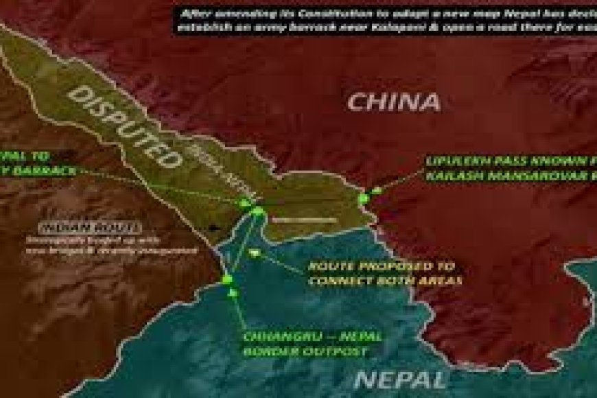
Located near the border with China, Lipulekh, Limpiyadhura and Kalapani are three strategically important areas claimed by both India and Nepal.
The issue surfaced in Parliament when CPN-UML lawmaker Paddma Aryal asked a question concerning disputed border areas between India and Nepal. While she did not specifically mention Lipulekh or Limpiyadhura, Shah's response referred to the broader issue of border encroachment.
Another legislator also asked about the matter, and Shah replied that instances of encroachment had occurred on both sides of the border. His statements were interpreted as referring to the long-standing dispute involving Lipulekh and Limpiyadhura.
Following the controversy, foreign ministry spokesperson Lok Bahadur Chhetri explained that the prime minister's comments were primarily related to encroachment in the no-man's-land zone, known in Nepal as the Dasgaja area. The parliamentary debate was about border occupation and cross-border use of land rather than any change in Nepal's territorial position.
The ministry reiterated that Nepal and India share a centuries-old open border and that Nepal's international boundary is based on the 1816 Treaty of Sugauli. It also stated that the border demarcation process in Limpiyadhura, Lipulekh and Kalapani sectors is still incomplete.
The dispute intensified in 2020 after India released a new political map showing Lipulekh, Kalapani and Limpiyadhura as part of its territory. Nepal strongly objected and demanded that the map be revised, arguing that the areas belong to Nepal.
Five months, Kathmandu released its own updated political map. On June 18, 2020, it amended its Constitution and formally incorporated Lipulekh, Kalapani and Limpiyadhura into the country’s official map.
India described the move as a "unilateral act".
Nepal's Cabinet also argued at the time that the source of the Mahakali or Sharda River lies in Limpiyadhura, an area administered by India's Uttarakhand state. That claim formed the basis of Nepal's argument that the disputed territory falls within its borders.
The announcement came shortly after India inaugurated a border road in the Lipulekh region. The route serves as an important access point for pilgrims travelling to Kailash Mansarovar in Tibet through China.
Nepal strongly objected, saying India had constructed a 22-kilometre road in territory claimed by Kathmandu. New Delhi has consistently rejected Nepal's claims and maintains that Lipulekh, Kalapani and Limpiyadhura are part of Indian territory.
The issue has a strong political and emotional weight in Nepal. The dispute led to large protests in 2020 and continues to be one of the country's most sensitive foreign policy subjects.
Lipulekh is located at a strategic tri-junction connecting India, Nepal and China. And therefore, any development in the area extends beyond the India-Nepal relationship.
In 2025, India and China agreed to resume trade through three designated routes of Lipulekh Pass, Shipki La Pass and Nathu La Pass. Border trade had largely stopped after the 2020 Galwan Valley clash between Indian and Chinese troops in eastern Ladakh.
A few months earlier, in December 2024, the two countries had also agreed to restart the Kailash Mansarovar Yatra through this route.
The announcement that trade would resume through Lipulekh led to objections from Nepal. Kathmandu said it had asked India not to carry out road construction, expansion work or trade activities in the disputed area.
Nepal's foreign ministry stated, "It is also clear that the Government of Nepal has informed the Government of China that this territory is part of Nepal."
India responded by saying that border trade through Lipulekh had existed since 1954 and had continued for decades. Foreign ministry spokesperson Randhir Jaiswal said the arrangement had been interrupted by Covid-related restrictions and other factors, but both countries had now agreed to resume it.
This was not the first time Nepal objected to India-China cooperation in the area. In 2015, when New Delhi and Beijing signed agreements to promote trade and commerce, Kathmandu formally lodged it protest, arguing that neither country had consulted Kathmandu despite the fact that the proposed route passed through territory claimed by Nepal.
The roots of the dispute go back more than two centuries. India and Nepal share a border stretching roughly 1,850 kilometres across Sikkim, West Bengal, Bihar, Uttar Pradesh and Uttarakhand. Despite years of joint efforts, survey teams from both countries have not been able to produce a border map accepted by both sides.
According to a report by former Nepal Survey Department Director General Buddhi Narayan Shrestha, Indian and Nepali officials jointly prepared maps in 1850 and 1856.
He argues that the Mahakali River originates from Limpiyadhura, about 16 kilometres northwest of Kalapani. Since the 1816 Treaty of Sugauli identified the river as the boundary between the two countries, Nepal considers Kalapani part of its territory.
India does not accept these maps as conclusive evidence. It argues that greater weight should be given to an 1875 map, which places the source of the Mahakali River east of Kalapani and supports New Delhi’s claim over the disputed region.
More than two centuries after the treaty was signed, Lipulekh, Kalapani and Limpiyadhura are still part of one of the most complex border disputes in the Himalayas, involving not only India and Nepal but also China's strategic interests in the region.